Cape St Lawrence and Meat Cove Area Hiking Trails.
The Cape St Lawrence and Meat Cove area hiking trails are located at the extreme northern tip of Cape Breton and offers some of the most spectacular scenery in this part of Canada, having hiked in many places from the west coast to the east coast this trail system is firmly in my list of top 10 Canadian hiking trails, at this time it has the added advantage of being relatively unknown.
This website started as a result of spending a few very pleasant days hiking the area trails in the height of summer and on every day we meet up with one or two lost souls, as map making and playing with a GPS is one of my hobbies I decided to put these maps together in the hope that they are useful to others.
Following the links will take you to larger scale maps and downloadable pdf files for easy printing, the descriptions included are a basic technical description of distances, elevations and significant landmarks. Where possible I have included links to other websites with more detailed descriptions and photos.
Trail Descriptions
Victor M Fauberts' excellent description of these trails and others with photos
TrailPeak Website trail description and photos
Area Businesses
serves as a “Welcome” Community Centre/Internet Cafe, that offers full menu service. It includes a tourist information centre, an emergency/first aid centre, a small genealogy centre, and a Tea Room.
I highly recommend a stop here the friendly folks can answer any questions you might have on the trails, accommodations and local businesses.
5 rooms with spectacular views
You won't find find a campground with a more spectacular view anywhere, also has rustic cabins for rent
902 383 2379
Other Hiking Information
Trail Heads of Nova Scotia a GPX file that can be loaded to most GPS units or used with Mapsource showing over 100 trailheads outside the Halifax region, users of Mapsource can also access links to websites with more details on many trails.
CONTACT me
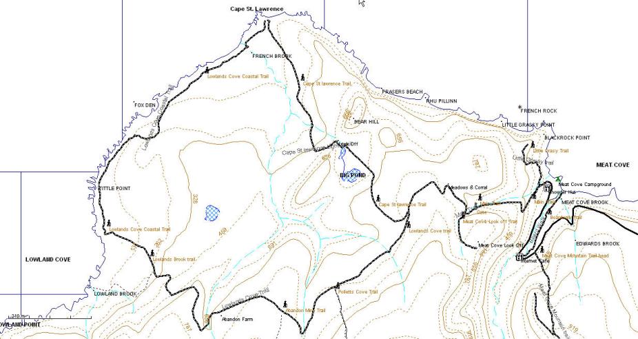
Larger Maps, Trail Descriptions & Downloads Can be found Here
Cape St Lawrence Trail 5km one way from campground, maximum elevation 850ft.
Lowlands Cove Trail 5km one way from Cape St Lawrence turnoff, 7km from camp ground
Lowlands Cove Coastal Trail 3.2km grasslands trail
Meat Cove Look Off 0.5km side trail to look off at 800ft
Little Grassy Trail 0.6km from campground overlooking Meat Cove at an elevation of 420ft, change in elevation 320ft
Meat Cove Mountain Trail 1.3 km to look off at end of ridge elevation 1040 ft with an additional 1km of ridge trails
River Boardwalk Trail 0.85 km to beach change in elevation 150 ft.
Abandoned Mine Trail 1.5 km side trail to an abandoned zinc mine, condition unknown. check locally
Polletts Cove Trail There used to be a trail along an abandon telegraph line between Meat Cove and Pollets cove, it hasn't been maintained in over 30 years and should no longer be considered passable, by all accounts the trail was boring and momentous passing through many miles of low bush and boggy terrain. Polletts Cove is easier to access from the Pleasant Bay area as a rugged one day or multi day hike a description of the trail can be found here.
Lowlands Cove to Pollets Cove caution their is no trail and I haven't personally attempted this but I recently talked to a very experienced hiker who has done this with a buddy. This gentleman is a very experienced hiker used to bushwhacking and his impression was that it wasn't hard as bushwhacking goes, he started from the Lowlands Cove road fairly close to the coast and as far as terrain allowed kept the coast insight, whenever forced to go inland by terrain or vegetation he headed back towards the coast as soon as possible. It only required 2 overnight camps before he reached Pollets Cove, according to him it was important to have a good paper map and read the terrain ahead when picking the route you can get stuck for a long time in wet areas or heavy bush if you read the land ahead wrong, hence this should only be attempt by suitably experienced people, the is no radio coverage in the area. If you have attempted this route I would love to hear any information particularly GPS data.
Polletts Cove/Aspy Fault Trail This 1998 proposed trail system would have been a hikers paradise of over 100km of trails, campsites, and shelters and a major economic stimulus for the area, sadly for a variety of reasons it never got built, and probably never will as originally proposed. Recently there has been some local interest in expanding the trail system and this original proposal is getting looked at again, if you would like more information or are interesting in helping please use the contact me link on this page. Hopefully one day part or all of a trail based on the original idea will see the light of day.
Description of the original proposal
Map of the Original Proposed Trail 3.4M pdf file
The Trails are a combination of old roads, open grass land and narrow forested trails sturdy footwear is advisable. Much to its credit the local community has recently undertaken considerable work on these trails adding many kilometers of new trails.
Hazards Other that the short trails around Meat Cove these are back country trails prepare accordingly. as a minimum take water and extra clothing.
Moose, deer, bears, cattle and horses can be found in the area, the horses are very friendly, pets should be kept under control at all times.
Hunting is allowed in this area, wearing bright coloured clothing is advised during hunting season.
Geocaches not surprisingly there are a number of geocaches hidden that are accessible from the trails.
GPS Track (.gpx file) from Meat Cove campground to Lowlands Cove along the Coast to Cape St Lawrence and returning via the Cape St Lawrence trail with a side trail to Meat Cove Look off