|
|
Cape St Lawrence Hiking
Trails printable .pdf
file follow links for more details
|
|
|
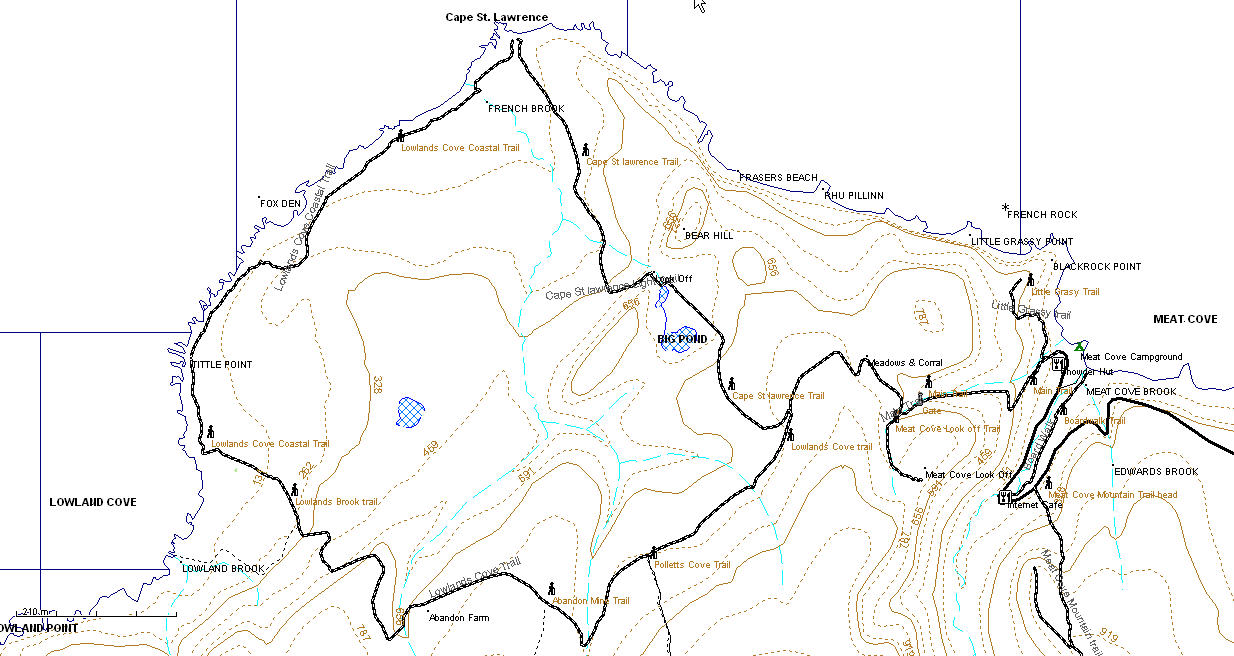
Cape St Lawrence Trail 5km one way from campground, maximum elevation 850ft. Lowlands Cove Trail 5km one way from Cape St Lawrence turnoff, 7km from camp ground Lowlands Cove Coastal Trail 3.2km grasslands trail Meat Cove Look Off 0.5km side trail to look off at 800ft Little Grassy Trail 0.6km from campground overlooking Meat Cove at an elevation of 420ft, change in elevation 320ft Meat Cove Mountain Trail 1.3 km to look off at end of ridge elevation 1040 ft with an additional 1km of ridge trails River Boardwalk Trail 0.85 km to beach change in elevation 150 ft Abandoned Mine Trail 1.5 km side trail to an abandoned zinc mine, condition unknown. check locally Pollets Cove Trail This multi day hike along old roads and an abandoned telegraph line trail should only be considered by the most experienced hikers with advanced navigational skills. Condition unknown, check locally.
Cape St Lawrence Trail . Trail length 5km one way, maximum elevation 850ft. This Trail starts by the Office at the campground (check with office if you plan to leave your vehicle near here) on the gravel road and changes to a narrow track after 150 meters and proceeds up the hill. This is by far the steepest and most challenging part of the hike in the first kilometer you will climb nearly 700ft and pass by a wooden gate and the sign for the Meat Cove Look Off trail to your left, by the time you reach a meadow and corral to your right most of the climbing is finished. About 2 kilometre from the start you will see the side trail to Cape St Lawrence to your right, as of July 09 this was well marked with flagging tape on both sides, it’s the first trial to your right past the meadows of any size and suitable for an ATV or horse and cart originally. The rest of the hike is an easy 3km proceeding gradually down hill except for one short steep section, be sure to check the look off at the top of this section just past Big Pond.
Lowlands Cove Trail 5km to the coast from the Cape St Lawrence turn off or 7 km from the camp ground. Instead of taking the Cape St Lawrence turn off at the 2 km mark keep straight on after another kilometre you will see the Pollets Cove turn off to your left, after about another kilometer you should see the disused road and trail to the abandon zinc mine (1.5 km), another 0.75 km takes you to an abandoned farm all that remains is a clearing and some farm implements. The trail proceeds gradually down to the coast, the topographic map indicates a side trail to Lowlands Cove Brook starting 0.7 km from the coast, I was day dreaming and totally missed this turn off, judging by the stunning scenery it would be worth locating.
Lowlands Cove Coastal Trail 3.2 km coastal trail. Just keep a safe distance from the cliff edge and follow ATV and animal tracks along the coast. If proceeding from Lowlands cove the Cape St Lawrence Light and start of the trail to Meat Cove is easy to find, proceeding the other way to Lowland Cove be on the look out for the trail just before the grassy area changes to a wooden area as Lowlands brook is approached, steel posts painted red mark the trail there are a couple located close to where the trail starts inland.
Meat Cove Look Off Start by following the directions for the Cape St Lawrence trail, this 0.5 km side trail is located 1 km from the campgrounds after a steep climb on a sharp corner where the road crosses a brook. As of July 09 it was clearly marked with a sign, the trail is clearly marked with flagging tape (July 2009). The trail rises 150ft from its start to a stunning view of the valley and Meat Cove
Little Grassy Trail This 0.6km trail starts on the right hand side of the road as you head up the hill just past the campground office and is marked with flagging tape. From the road it drops down to the creek then gradually rises to a knoll overlooking the coast and Meat cove from a height of 420 ft. If you only have time for one trail this should be the one, it offers stunning views for the least effort of any trails in the area.
Meat Cove Mountain Trail 1.3 km to eastern end of ridge. This trail starts a short distance up the road from the Internet Café and is marked by a small sign on a tree, and a few stones placed to form steps, the trail climbs steeply nearly 900ft in the first 0.75km and then levels off somewhat. The grassy ridge of the mountain extends over a kilometer with fantastic views in all directions.
River Board Walk Trail This pleasant boardwalk trail extends nearly a kilometre from the Internet Café to the beach
GPS Data
Cape St Lawrence light Turn
N47°01.423'W60°34.696'
GPS Track from Meat Cove campground to Lowlands Cove along the Coast to Cape St Lawrence and returning via the Cape St Lawrence trail with a side trail to Meat Cove Look off
Geocaches G4XAN8 Cape St Lawrence 47.041167 North 60.598017 West GCXANA The Fox Den 47.032167 North 60.611083 West GCXANC Lowland Cove 47.016417 North 60.620183 West GC1W9V8 Meat Cove Lookoff 47.02045 North 60.56905 West GC148CH Meat Cove Mountain 47.016367 North 60.561283 West GC1XRN9 Meat Cove Beach 47.02595 North 60.5579333333333 West These last 2 Geocaches are not on the trails but off the gravel road leading to Meat Cove and are not on the map above, they are just over 1 kilometre from the Internet Cafe GC1VHBP Jumping Brook Falls 47.02415 North 60.542967 West GCG407 Northern Tip of Cape Breton 47.025683 North 60.536267 West
About these Maps
These maps are compiled with data from Geo Gratis (see legal below) and GPS tracks from actual hikes, these trails are marked with a bold dashed line other trails may be indicated that I don't have the data for with a faint dashed line. If you have the data in GPX file format and wish to contribute please contact me.
Legal No guarantee is made as to the accuracy of these maps or suitability for any particular purposes, in some cases there are known inaccuracies.
The underlying data for these maps comes from the Geo Gratis website Department of Natural Resources Canada and as such is subject The Geobase Unrestricted Use License Agreement details of which can be found here http://www.geobase.ca/geobase/en/licence.jsp The use of this data does not construe the endorsement of any. third party.
This maps where made with free and open source software. You may make copies of them by print or electronically, and give them away, but under no circumstance may you sell them.
|